|
Reported Crop Circles for the State
of Minnesota -
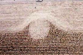
Blaine, Anoka County (October 24, 1994)
Single 47' circle discovered during harvesting. The lay was described as “generally clockwise” but also in a “somewhat erratic” direction. Although no evidence of prior human entry to the circle was discovered, three 6-inch diameter holes were discovered near the center of the circle spaced about 6 feet apart, and the stalks at the center were “smashed” to the ground. Stalks near the edge of the circle were bent at a 20º angle with the ground.
A white crystalline power consisting of Calcium, Silicon, Sulphur, and Sodium was found on the plants and soil in one small area of the circle. Under microscopic analysis, W.C. Levengood found that the crystals were of an unusual helical structure. He also found higher concentrations of spherical magnetite in the soil collected from the circle.

Crop
type: Corn (Maize)
Source and photos: Joel Henry, Minnesota MUFON, W.C. Levengood Lab Report No. 52
|
|
City
/ County / Date:
- Green
Lake, Kandiyohi County (May-Jun1909)
-
Stewart, McLeod County
(June 25, 1971)
-
[unknown], Meeker County (December 27, 1974)
- Waltham, Mower County (September, 1979)
- Albany Township / Lake City / Rochester, Wabasha County
(September, 1979)
- Fergus Falls, Otter Tail County (July 5, 1992)
- Lewis Lake (Milaca), Kanabec County (October 1, 1994)
-
Blaine, Anoka County
(October 24, 1994)
- Pease, Mille Lacs County (September 5, 1996)
- Hamel, Hennepin County
(July 11, 1999)
- Owatonna, Steele County
(August 1, 2000)
- North Long Lake, Crow Wing County (February, 2002)
- Litchfield, Meeker County
(July 4, 2004)
- Cottage Grove, Washington County (July 24, 2004)
- Lake Elmo, Washington County (October 18, 2004)
|


